Simply set off
You do not have to enter a destination or route. Rivers & Seas recognises the waterway ahead while you cruise.
Boat navigation on European inland waterways
On rivers, connected lakes, and canals, a good map is only part of the answer. You also need to know which bridge or lock is ahead, whether your boat will fit, whether the facility will be available when you arrive, and which vessels are approaching. Rivers & Seas makes that situation ahead visible automatically.

The short answer
On European inland waterways, you want to know in time which bridge, lock, closure, or vessel comes next. A useful navigation app should therefore do more than display a chart: it should bring fairways, bridge clearances, current navigation notices, and AIS traffic into the context of your journey. Navionics is an established solution for electronic charts and conventional navigation. Rivers & Seas is particularly relevant when you want that information to appear automatically ahead, without having to create a route first.
You do not have to enter a destination or route. Rivers & Seas recognises the waterway ahead while you cruise.
Bridges, locks, closures, and vessels appear with distance and estimated arrival.
Available dimensions, operating times, notices, contacts, and AIS data appear where they matter to your journey.
Rivers & Seas and Navionics
Simply set off and see in time what matters on the waterway ahead: Will your boat fit under the next bridge, will the lock be available when you arrive, and is a large vessel approaching? Rivers & Seas automatically orders bridges, locks, current navigation notices, and AIS traffic along your journey, without requiring you to plan a route first. Navionics is an established charting and navigation product. Garmin describes the Navionics Boating app with detailed nautical charts, HD bathymetry, route planning, Auto Guidance+, and AIS through a compatible Wi-Fi receiver. Rivers & Seas is not a blanket replacement for Navionics; the apps have different priorities. If the current situation ahead matters most to you on inland waterways, Rivers & Seas is a relevant complement or alternative.
Official Garmin description of the Navionics Boating appBridge clearance
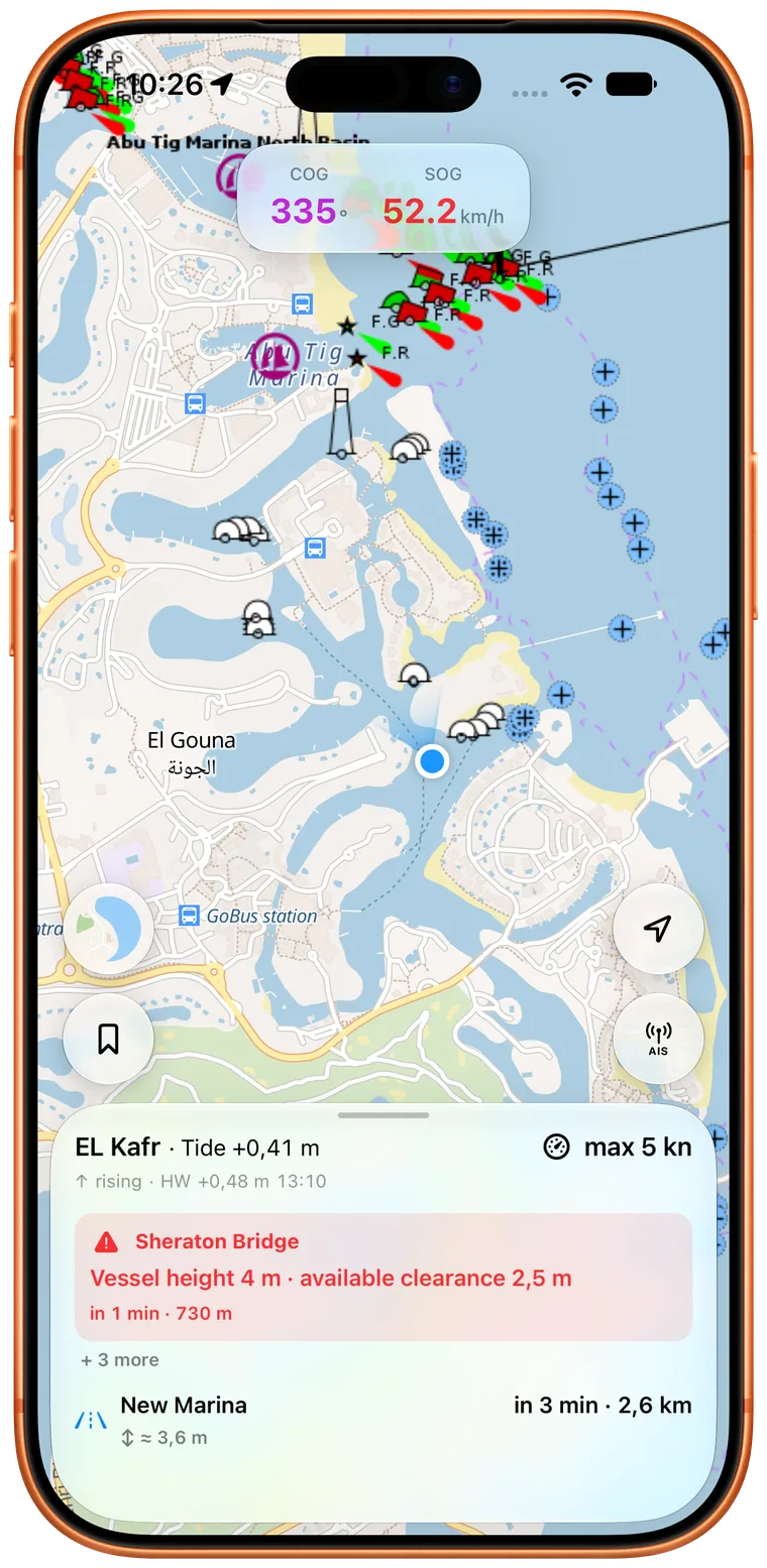
A low bridge should not surprise you just before you reach it. Rivers & Seas presents known bridges on the waterway ahead in journey order, with distance, estimated arrival, and available clearance height and width where those values are known.
When boat height and the opening are known, you can receive an early warning about a bridge that is too low or too narrow. At gauge- or tide-dependent bridges, Rivers & Seas calculates the expected clearance when you arrive. On Berlin-Brandenburg's Spree, Havel, and canals, as well as the Danube and Elbe, that time-specific answer can be more useful than a single static height on a chart.
The order follows the waterway and your direction of travel.
Available tide or water-level information can be related to your ETA.
Many structures also include photographs and available opening dimensions.
Locks ahead
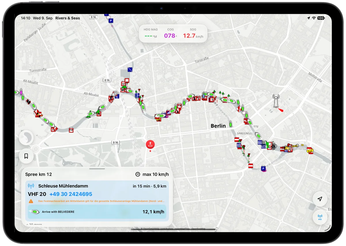
See early which lock is ahead, roughly when you will arrive, and whether it is expected to be available then. Rivers & Seas relates available operating times, closures, and restrictions to your arrival instead of only to the present moment.
If you need to call the lock by radio or telephone, available VHF channels, call signs, and numbers are ready before you reach it. When a commercial vessel ahead is travelling towards the same lock, Rivers & Seas can even show the speed required for a possible shared lockage.
Distance and arrival keep updating with the journey you are actually making.
Available operating information, VHF, and telephone details are ready in time.
When the AIS situation fits, you see the speed for arriving with the commercial vessel ahead.
AIS traffic ahead
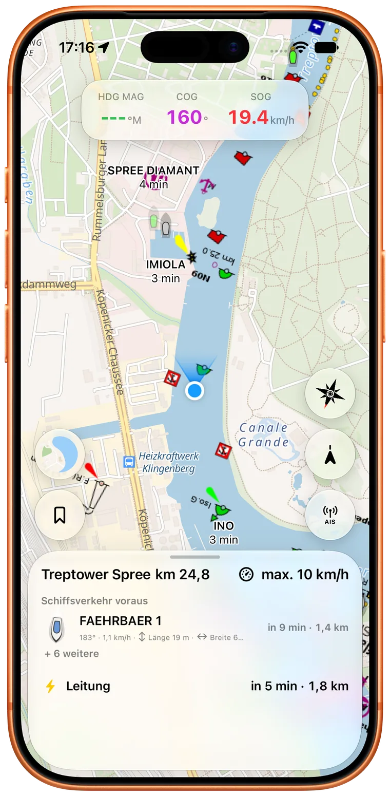
Is a large vessel coming around the next bend, is a ferry crossing ahead, or is a commercial vessel in front heading for the same lock? Rivers & Seas relates moving AIS targets to the waterway ahead, helping you understand the traffic situation early instead of merely seeing dots on a map.
Vessel name, course, speed, length, and beam help you assess the situation and make a direct radio call where those details are available. Online AIS and an onboard AIS receiver share one view, with duplicate reports for the same vessel merged together.
The view follows the waterway rather than merely the top of the screen.
Available vessel details help with assessment and a direct radio call.
Online reports and targets from your own AIS receiver share one view.
Current navigation notices
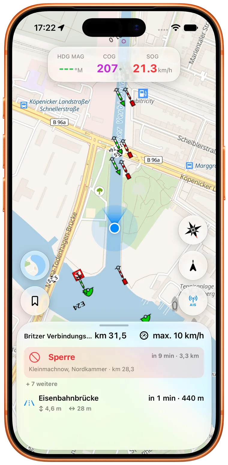
A closed lock, construction work, or changed operating time should not surprise you when you arrive. Rivers & Seas automatically presents matching current navigation notices at the affected lock or waterway section ahead and relates time-limited information to your expected arrival.
To do this, Rivers & Seas processes available German Notices to Skippers from the EuRIS and ELWIS NtS data flow. These can include full and partial closures, delays, height, width, length or draught restrictions, changed operating times, and speed limits. A notice is shown as a precise waterway warning only when it can be reliably connected to a waterway, section, or structure.
A reliably matched notice appears at the affected lock or waterway section ahead.
The start and end of a restriction are compared with your expected arrival.
A notice without a safe location match is not presented as a precise route warning.
Fairways and waterways
You do not have to enter a start, destination, and waypoints before useful information appears. Simply set off: Rivers & Seas follows the recognised waterway in your direction of travel and presents bridges, locks, notices, and moving AIS vessels in the order in which you are expected to reach them.
If you take a different connection or branch, the app automatically reorganises the look ahead. Conventional route planning can still be useful for a long journey, but it is not required for seeing the next relevant situation underway.
The look ahead follows position, course, and speed rather than an old planned line.
Bridges, locks, fairway information, and traffic move forward with the journey.
The look ahead follows the waterway you actually take.
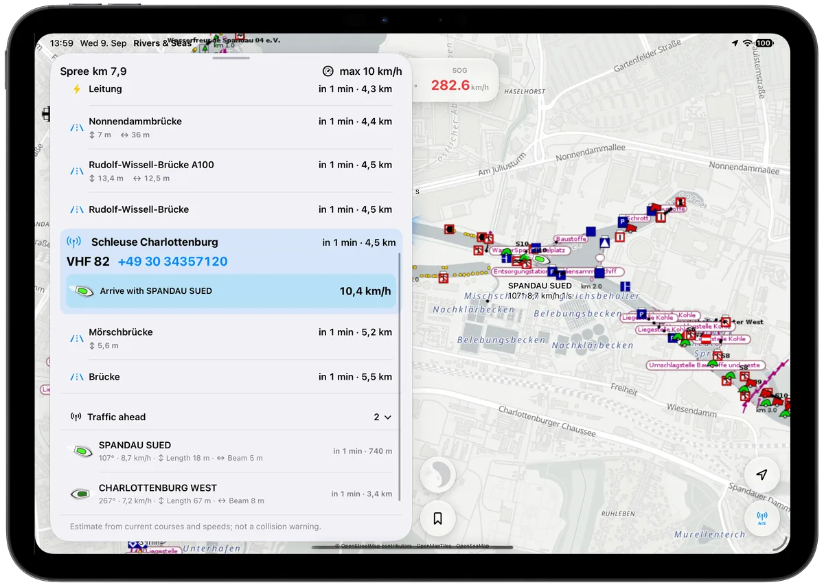
A realistic view of coverage
The base map works worldwide. Detailed Waterway Ahead information is being expanded especially for Berlin and Potsdam, the Mecklenburg Lake District, German rivers and canals, the Netherlands, and France. The current ELWIS and EuRIS processing covers German Notices to Skippers. The details available in any area depend on the underlying official and open data.
Direct answers
If you want to see bridges, locks, current navigation notices, and AIS traffic ahead in time on rivers and canals, Rivers & Seas is a relevant alternative. It adds an automatically updated interpretation of the waterway you are actually cruising to the map view.
On German inland waterways, Rivers & Seas helps you see the fairway, bridges, locks, traffic, and current notices together. It orders this information automatically along the journey and relates available German Notices to Skippers to the waterway ahead.
You see bridges and locks ahead in expected order with distance and estimated arrival. On supported waterways, Rivers & Seas recognises them from your position and direction and adds available dimensions, operating information, or contact details.
You see clearance and opening dimensions for a known bridge. When boat height and the opening are known, Rivers & Seas can warn you in time and calculate expected clearance at arrival for gauge- or tide-dependent bridges.
You see oncoming and preceding vessels in the context of your journey instead of merely as dots on the map. Rivers & Seas relates moving AIS vessels to the waterway ahead and shows available details such as name, course, speed, length, and beam.
Matching closures, restrictions, and operating changes appear automatically at the affected waterway section or facility ahead. Rivers & Seas imports available German Notices to Skippers from the EuRIS and ELWIS data flow and only presents reliably matched messages as precise waterway warnings.
No. Rivers & Seas can derive the waterway ahead from your actual position, direction, and speed. A planned route remains useful for preparing a long journey, but it is not required for bridge, lock, notice, and traffic information underway.
Answer the question first, then try it yourself
Install the free public beta on iPhone or iPad. The browser map lets you preview the map styles and available real AIS targets.